
Hunting drones equipped with real-time data systems are transforming how hunters locate and recover game. By combining thermal imaging, GPS, and live video feeds, these drones can scan vast areas quickly, even in challenging conditions like dense brush or darkness. This technology significantly cuts down search times, boosts recovery rates, and allows hunters to make faster, more informed decisions in the field.
Key takeaways:
- Thermal imaging detects heat signatures, helping locate animals up to 1,000 yards away.
- GPS and laser rangefinders provide precise coordinates for easy navigation.
- Real-time telemetry ensures drones operate efficiently, showing battery life, altitude, and signal strength.
- Faster recovery: Tasks that could take hours on foot are now completed in minutes with drone assistance.
- Future potential: AI systems can identify animal species and alert users instantly.
This guide explains how real-time data works, the equipment needed, and setup tips to get the most out of your hunting drone.
Real-Time Hunting Drone Performance: Key Statistics and Benefits
Fast Recovery Using Thermal Imaging Drone 
sbb-itb-31b92c7
What Is Real-Time Data in Hunting Drones
Real-time data transmission in hunting drones refers to the process of collecting, analyzing, and delivering critical insights from the drone to your controller or mobile device while the drone is still in flight. This immediate flow of information – such as thermal images, GPS coordinates, battery status, and flight metrics – gives hunters the tools to make quick decisions in ever-changing field conditions.
Here’s how it works: the drone captures data using onboard sensors, transmits it through high-speed communication links, processes it with edge computing or AI, displays live feeds and telemetry, and allows for real-time adjustments during flight.
"Telemetry is what brings unmanned vehicles to life in ways a human pilot alone cannot." – Beyond Sky
The Technology Behind Real-Time Data
This system hinges on a combination of advanced components:
- Thermal Sensors: These detect heat signatures, making it possible to locate animals even in dense brush or complete darkness.
- Telemetry Systems: Provide constant updates on the drone’s position, altitude, speed, and battery health.
- Communication Links: Use protocols like MAVLink for compatibility and employ techniques like frequency hopping to minimize signal interference.
- Data Transmission Range: Internal radios can transmit data up to 19 miles (30 km), extendable to 31 miles (50 km) with booster packages.
Benefits for Hunters
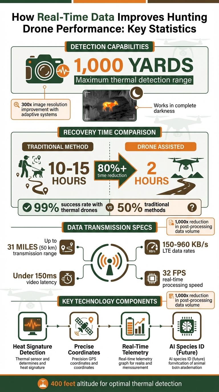
For hunters, this technology translates to faster, more accurate decisions and improved efficiency. Live thermal feeds and precise GPS coordinates allow for rapid targeting, regardless of lighting conditions. Thermal imaging is effective any time of day, as long as there’s enough temperature contrast between the animal and its surroundings. Pairing this with a laser rangefinder enables you to mark a GPS location on a target and navigate directly to it, even if it’s 1,000 yards away in dense terrain.
Drone-assisted recovery is another game-changer. What might take 10 to 15 hours manually can be reduced to just 2 hours with drone assistance. LTE-based data transmission offers flexibility, with rates ranging from 150 KB/s to 960 KB/s depending on the quality of the stream and cellular signal strength. As edge computing and AI continue to evolve, future systems could automatically identify animals and alert you in real time, eliminating the need for manual image analysis.
These advancements are setting the stage for new levels of performance and efficiency in the field, paving the way for even more impressive capabilities ahead.
Performance Improvements from Real-Time Data
Better Scouting and Game Tracking
Real-time thermal sensors open up possibilities that traditional methods simply can’t match. These sensors detect heat signatures through dense brush, tall grass, and even in complete darkness. For example, while conventional methods recover wounded deer only about 50% of the time, drones equipped with thermal imaging can locate a carcass from as high as 400 feet without disturbing the surrounding wildlife.
When a drone’s thermal sensor picks up a heat signature, its onboard laser rangefinder marks the exact GPS coordinates. This allows hunters to navigate directly to the animal. You can also scout movement corridors and bedding areas from high altitudes, minimizing disruption to the game. For the best results, conduct thermal scouting during early morning or late evening hours, when the ground is coolest. This timing enhances the thermal contrast between the animal’s body heat and the environment. Using grid or zig-zag flight patterns further ensures that heat signatures are effectively captured over large, uneven areas.
But the value of real-time data goes beyond just locating targets – it also enhances your overall awareness of the environment.
Increased Awareness of Surroundings
Live data feeds provide a bird’s-eye view of areas that are hard to access on foot. Dual-sensor systems, which combine thermal imaging for broad detection and high-resolution RGB zoom for detailed identification, offer a more complete picture. This technology helps verify targets before any action is taken, reducing false positives caused by rocks, machinery, or sun-warmed surfaces.
Advancements in real-time imaging technology are impressive. For instance, adaptive systems can improve image resolution by up to 300 times, while selective high-resolution imaging cuts down post-processing data volume by as much as 1,000 times. In a 2024 study at the Haiderpur wetland in India, researchers used real-time object detection to count 77 swamp deer with a precision score of 90.7%, processing data at 32 frames per second on a local server. These capabilities translate seamlessly into hunting, enabling real-time species identification, herd health checks, and animal counts – all without the need for manual data review.
Quicker Field Decisions
When tracking wounded game, time is critical. Drones equipped with thermal imaging can significantly reduce search times. What might take hours with traditional methods can often be completed in just minutes of flight.
"A thermal drone lets you scan from above and locate body heat instead of relying on guesswork. This shortens recovery time and helps prevent wounded animals from being lost." – Paul Aitken, CEO, DroneU
Real-time telemetry also keeps you informed about crucial metrics like battery life, altitude, and signal strength, ensuring safe and efficient drone operation. Tools like Skydio Scout allow drones to autonomously follow a GPS position – whether it’s your location or that of a tracking dog – providing continuous overhead coverage without requiring manual control. This means you can focus on the hunt rather than worrying about piloting the drone.
Looking ahead, AI-powered detection systems are set to take things even further. These systems will automatically identify specific animal species and send real-time alerts, removing the need for manual interpretation of thermal images. Additionally, Team Awareness Kits (TAK) already enable live drone feeds and shared location data across devices, making it easier to coordinate with your hunting team in real time. This kind of instant data access not only speeds up decision-making in the field but also promotes more ethical and efficient hunting practices.
Setting Up Your Hunting Drone for Real-Time Data
Selecting the Right Drone and Accessories
When setting up your hunting drone, start by ensuring it includes a telemetry system. This system provides real-time updates on critical details like location, speed, battery status, and sensor data. For seamless communication with ground control software, opt for drones that support MAVLink.
You’ll also need to decide on a transmission option. Internal radio systems operating on 900 MHz or 2.4 GHz can cover distances of 20–30 miles. Alternatively, LTE/5G cellular networks offer nearly limitless range, as long as cell towers are nearby. The Sky Drone FPV 3, for instance, is a complete package priced at $1,499.00. It includes a 4G/5G unit, a camera, and telemetry cables for real-time streaming.
Low video latency is crucial when tracking fast-moving game. Look for systems that achieve a glass-to-glass latency under 150 milliseconds by using specialized UDP pipelines. Many systems also feature auto-bandwidth adaptation, which adjusts frame rate, resolution, and compression based on signal strength. For reference, streaming in full HD at 6 Mbit/s uses about 450 MB every 10 minutes, while a low-quality stream at 50 kbit/s consumes under 4 MB for the same duration.
To keep your data secure, make sure your system uses AES-256 encryption to block unauthorized access to video and command links. For flexibility in hunting scenarios, consider drones with interchangeable lenses. A wide-angle lens is great for scouting large areas, while a narrow field-of-view lens is better for identifying specific targets.
Once you’ve selected your drone and accessories, the next step is configuring your data transmission systems.
Setting Up Data Transmission Systems
Proper antenna orientation is key for stable data transmission. Position telemetry antennas vertically, with the side facing the drone – never point the antenna tip directly at the aircraft. Place your ground station on a non-metal surface, such as an elevated platform, and avoid setting it on cars, metal tables, or directly on the ground. Maintain a clear line of sight between the drone and the ground station, as obstacles like trees, hills, and buildings can interfere with the signal. Stay away from transmission towers and high-voltage cables to reduce interference.
For drones using LTE networks, ensure the SIM card has no PIN lock and enough data for high-bandwidth streaming. Test LTE connectivity beforehand by checking the dongle on a laptop. Adjust the stream rate based on signal strength, ranging from 150 KB/s in areas with weak signals to 960 KB/s in areas with strong connections.
When updating firmware, always start with the drone’s station modules, then move to the ground station. This ensures the drone reconnects smoothly after rebooting. If your data link becomes unreliable mid-flight, temporarily disable the video feed to prioritize telemetry for flight control.
With these systems in place, it’s time to focus on maintenance to keep your drone running smoothly.
Drone Maintenance and Updates
Regular maintenance is essential to keep your drone operating effectively. After any rough landings, carefully inspect the drone for physical damage and ensure all connections are secure, as vibrations can disrupt data flow. Check the drone body for cracks, inspect propellers for wear, and clean the motors to prevent performance issues caused by imbalances.
Keep firmware updated monthly or as new releases become available. Updates often fix bugs, reduce latency, and add new features. Enable telemetry logging to a CSV file on your radio’s SD card. This allows you to review link performance and recover GPS coordinates if the drone crashes.
Before every flight, verify your data link. Check signal strength indicators and MAVLink data flow in your ground control software. After hardware changes, use your radio’s "Discover new sensors" function to confirm all data points – like GPS, voltage, and RSSI – are being received. If you rely on cellular data, ensure your SIM cards are active and have enough data each month.
Weather can also affect performance. Rain and fog may weaken wireless links, so adjust your flight strategy or use protective coverings in bad weather. Finally, mount telemetry modules away from other antennas and metal components on the drone to minimize interference.
Conclusion
Real-time data is transforming the way hunting drones operate, bringing a new level of efficiency and precision to the field. With instantaneous data analysis, hunters can adapt to changing conditions on the spot, cutting down delays and increasing their chances of success.
Thermal imaging technology allows drones to scan large areas quickly, identifying heat signatures from as far as 1,000 yards – something that would be nearly impossible on foot. Beyond performance, there are ethical advantages as well. Real-time thermal data helps hunters locate wounded animals more quickly, promoting responsible hunting practices. As Ron Howell, Head of Enforcement Division at Montana Fish, Wildlife & Parks, puts it:
"We obviously don’t want meat to go to waste. We want hunters to recover their game, field dress it and take care of the animal. That’s what we care about".
These advancements lead to significantly better recovery rates. Professional drone recovery services using thermal imaging report success rates as high as 99%, compared to just 50% with traditional tracking methods. Features like onboard laser rangefinders provide precise GPS coordinates, making navigation straightforward. Additionally, modern systems streamline post-hunt analysis by reducing data volume up to 1,000 times, focusing only on relevant thermal anomalies.
To make the most of these advancements, invest in equipment with cutting-edge features like thermal imaging, high-resolution zoom, and integrated telemetry. These tools not only improve recovery rates and shorten search times but also enhance overall hunting outcomes.
For expert advice and recommendations on the best outdoor gear, check out Scope It Outdoors.
FAQs
Is using a hunting drone with thermal imaging legal where I hunt?
The use of hunting drones equipped with thermal imaging is often heavily regulated. States like Colorado, Oregon, and Texas generally ban their use for hunting unless specific authorization is granted. It’s crucial to review local laws carefully, as operating these devices without the necessary permits is usually against the law.
Should I use LTE/5G or a radio link for real-time video and telemetry?
When it comes to real-time video and telemetry, LTE and 5G often outperform other options. Their high bandwidth, low latency, and extended range make them ideal, especially for tasks like beyond visual line-of-sight (BVLOS) operations.
On the other hand, while radio links can get the job done, they come with limitations. Their range is more restricted, and they are more susceptible to interference, which can impact reliability.
Ultimately, the choice depends on your specific requirements and the conditions in which you’re operating.
What’s the best way to avoid losing signal in woods or hilly terrain?
To keep your drone connected without losing signal, it’s important to maintain a clear line of sight between your drone and its controller. Avoid obstacles like trees, hills, or buildings that could block the signal. Make sure the antennas are positioned correctly – keeping them vertical works best – and set up the ground station in the right spot. Flying at a suitable altitude can also help cut down on signal interference. If you’re operating in areas where connectivity is tricky, consider using range extenders or signal boosters to strengthen the connection.